Desert Star Project
California, USA
Location
The Desert Star Project is located in San Bernardino County within California’s eastern Mojave Desert and comprises 72 federal lode claims covering approximately 6 km². Strategically positioned just 4.5 km northeast of the world-class Mountain Pass Rare Earth Mine and 4.7 km from the Colosseum Gold Mine, the project lies within a globally significant REE – gold corridor.
The project is easily accessible via a network of paved highways and gravel roads extending from Interstate 15. The nearest service center is Primm, Nevada, approximately 12 km to the east, while Las Vegas lies just 85 km to the northeast, offering full commercial support and logistics. The area benefits from well-developed infrastructure, including power transmission lines servicing the nearby Mountain Pass Mine and a Union Pacific rail line within 25 km offering potential access for bulk transport and future energy supply. The regional energy network is further supported by renewable power generation, including large-scale solar facilities in Ivanpah Valley, which contribute to a stable and sustainable green energy grid.

Desert Star Project Location Map
Geology
The Project is located within a structurally complex zone of the eastern Mojave Desert, spanning a geological transition from Paleoproterozoic metamorphic basement rocks in the west to Cambrian marine sedimentary units in the east. The basement is composed of high-grade gneisses and schists, while the overlying Cambrian sequence includes limestones, quartzites, and shales, part of a broader assemblage of Paleozoic sediments and volcanics recognised throughout the Mountain Pass – Colosseum corridor.
REE mineralisation is interpreted to be associated with carbonatite-hosted systems enriched in bastnaesite, parisite, and other REE-bearing minerals. Alteration assemblages comprising barite, fluorite, hematite, phlogopite, and calcite are consistent with a magmatic-hydrothermal origin. Regional tectonism has facilitated emplacement along a northwest-trending structural corridor, bounded by the Ivanpah and Clark Mountain fault systems.
Highlights
- Tier-1 Jurisdiction: Situated in the prolific Mountain Pass district of California, a globally recognised rare earth elements (REE) hub and the only active commercial REE mining region in the United States.
- Proximity to World-Class Deposit: Located just 4.5 km from MP Materials’ Mountain Pass REE Mine, one of the highest-grade and most significant rare earth operations globally.
- Highly Prospective Geology: Hosted within the same Precambrian terrane and structural corridor that controls REE mineralisation at Mountain Pass. The project area features Mesoproterozoic carbonatite and alkaline intrusives known to host REEs.
- Compelling Geophysical Signatures: USGS airborne radiometric survey data shows elevated potassium (K), thorium (eTh), and uranium (eU) concentrations, consistent with surface expressions of REE-hosting carbonatites.
- Multi-Commodity Potential: In addition to REEs, the district is considered prospective for gold and antimony, offering diversified commodity exposure in a critical minerals corridor.
- Excellent Infrastructure: The project benefits from nearby paved roads, grid-scale transmission infrastructure, and a Union Pacific rail line just 25 km from site—offering logistics advantages for future development and transport.
- Strategic Supply Chain Relevance: Located within the United States’ domestic rare earth supply chain, Desert Star aligns with growing geopolitical priorities around securing non-Chinese sources of critical minerals.
- Exploration Program Underway: Initial field activities including geological mapping and targeted surface sampling have commenced. Results will inform future phases, including potential drill target delineation.
- Low-Cost Entry with High Leverage: Early-stage tenement secured through direct claim staking in a proven REE district offers significant upside potential with minimal upfront capital.
- Data-Driven Targeting: Integration of historical datasets, modern radiometric surveys, and detailed lithostructural mapping supports focused exploration and de-risks early-stage targeting.

Desert Star Project Location Over Regional Geological Map

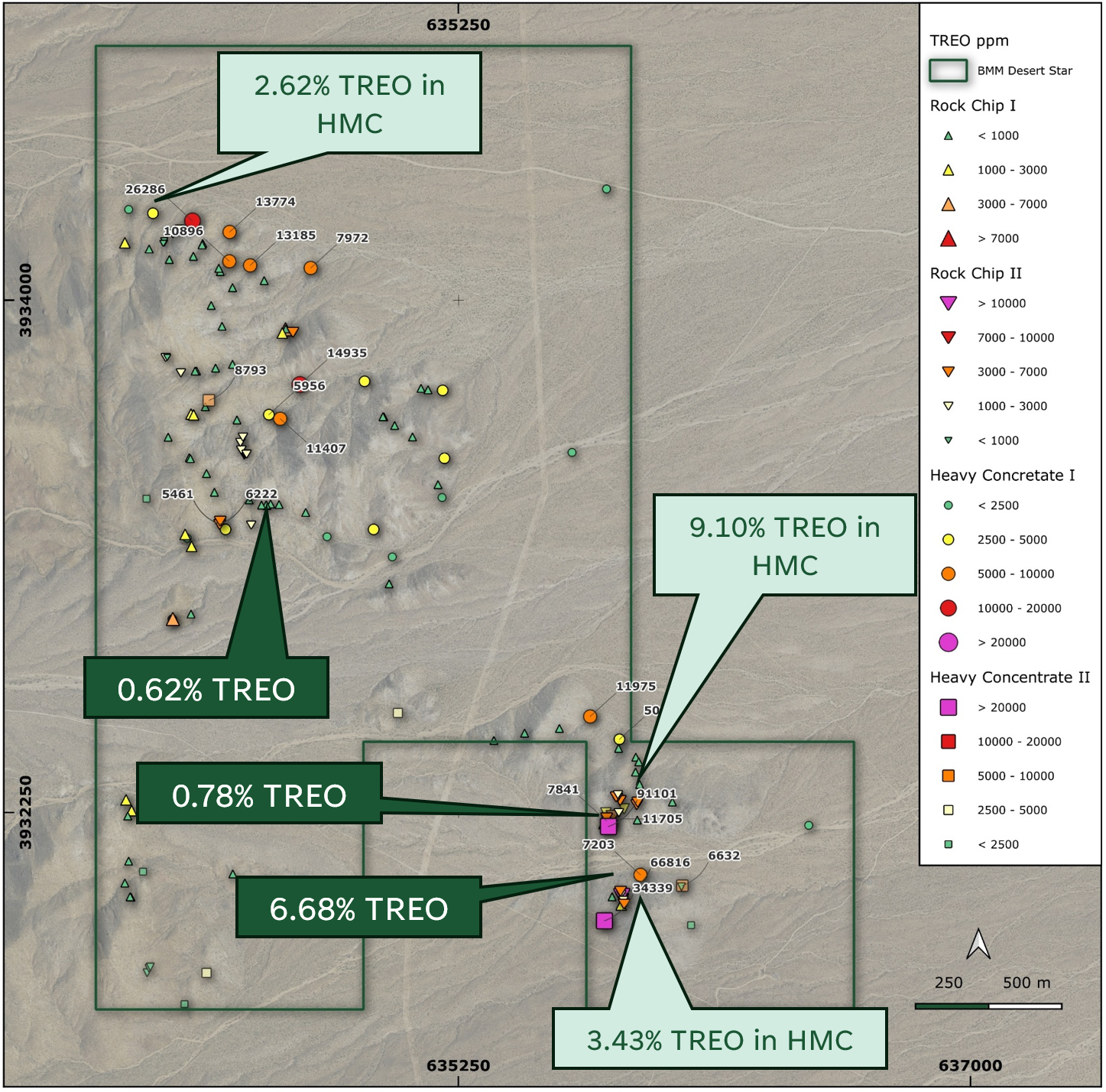
Collected rock chips and heavy minerals concentrate samples

Field photo of young alluvial pan crosscutting basement metamorphic and felsic plutonic rocks
Exploration Activity
Surface Geochemistry Survey and Assessment
A comprehensive surface chemistry survey was conducted in Q3 and Q4 2025 with the highlights detailed below1:
Heavy Mineral Concentrate Samples:
| 91,092 ppm TREO (Sample 19597) | 14,935 ppm TREO (Sample 19419) |
| 34,330 ppm TREO (Sample 19598) | 13,774 ppm TREO (Sample 19441) |
| 26,286 ppm TREO (Sample 19440) | 11,975 ppm TREO (Sample 19421) |
Surface Samples:
| 66,810 ppm TREO (Sample 19583) | 5,458 ppm TREO (Sample 19594) |
| 7,841 ppm TREO (Sample 19415) | 4,979 ppm TREO (Sample 19544) |
| 6,220 ppm TREO (Sample 19593) | 4,551 ppm TREO (Sample 19569) |
- Refer to ASX Announcement dated 1 September 2025 and 21 January 2026 for the complete set of assay results ↩︎
REO distribution indicators and magnet REE context
As part of the REE distribution assessment for the selected high-grade samples, the Company has calculated indicative LREO and HREO proportions within TREO, where LREO is defined as La2O3 + CeO2 + Pr6O11 + Nd3O3 + Sm2O3 + Eu2O3 and HREO as Gd2O3 + Tb4O7 + Dy2O3 + Ho2O3 + Er2O3 + Tm2O3 + Yb2O3 + Lu2O3 + Y2O3.
The three (3) samples are strongly LREO dominant (LREO approximately 94% of TREO) and include a material Nd-Pr (magnet REE) component approximately 23-29% of TREO. These calculated proportions are indicative and will be reconciled with ALS Mineralogy and Spectrum petrographic results to confirm host minerals and key textural controls.
| Indicator | 19583 | 19597 | 19598 |
| LREO (% of TREO) | 94.39% | 93.91% | 93.92% |
| HREO (% of TREO) | 5.61% | 6.09% | 6.08% |
| LREO/HREO | 16.83 | 15.42 | 15.45 |
| (Nd2O3+Pr₆O₁₁)/TREO (magnet REE) | 23.68% | 29.32% | 23.32% |
| (Dy2O3+Tb4O7)/TREO | 0.87% | 0.94% | 0.83% |
Geophysical Analysis
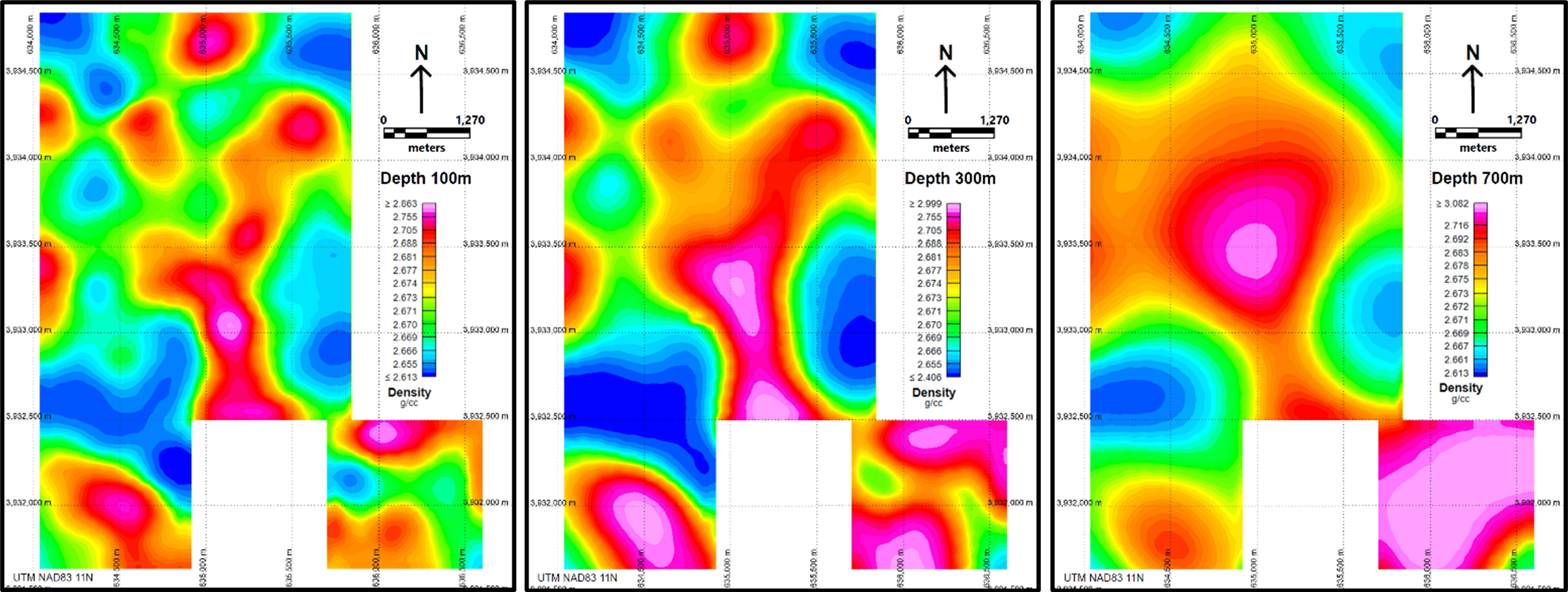
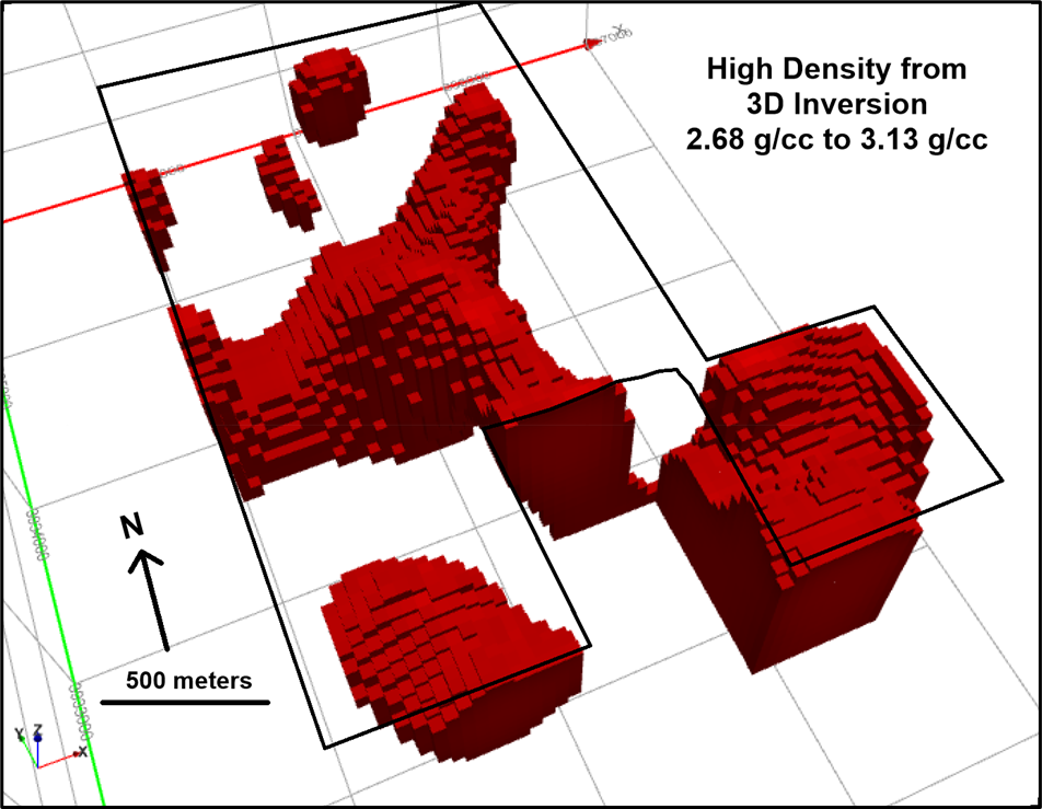
In Q4 2025, Bayan completed a magnetics, radiometric and gravity surveys over the Desert Star project. These results were by by Bayan Technical Advisor, Mr Robert (Bob) Ellis, formerly a Geophysicist at Molycorp (the previous operator and developer of Mountain Pass before MP Materials Corp), at the Mountain Pass Mine provides strong, district experience technical validation.
3D magnetic vector inversion defines low‑susceptibility features coincident with central density highs that support a carbonatite model comparable to Mountain Pass, with the main target commencing at ~100 m depth and susceptibility lows strengthening from ~300 m to at least 700 m along a NW‑trending corridor and the southern project boundary, and higher‑susceptibility sources mapped in the southeast and southwest of the Desert Star project.